


le verdet

franquen
User
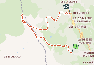

Length
9 km

Max alt
2285 m

Uphill gradient
498 m
Km-Effort
16.8 km

Min alt
1432 m

Downhill gradient
853 m
Boucle
No
Creation date :
2021-01-07 09:31:38.626
Updated on :
2021-01-07 13:45:54.91
2h24
Difficulty : Easy

FREE GPS app for hiking
 SityTrail
IGN / Geographical institutes
SityTrail Plus
The world is yours!
About
Trail Touring skiing of 9 km to be discovered at Auvergne-Rhône-Alpes, Savoy, Les Allues. This trail is proposed by franquen.
Positioning
Country:
France
Region :
Auvergne-Rhône-Alpes
Department/Province :
Savoy
Municipality :
Les Allues
Location:
Unknown
Start:(Dec)
Start:(UTM)
309636 ; 5027442 (32T) N.
Comments